
Abstract
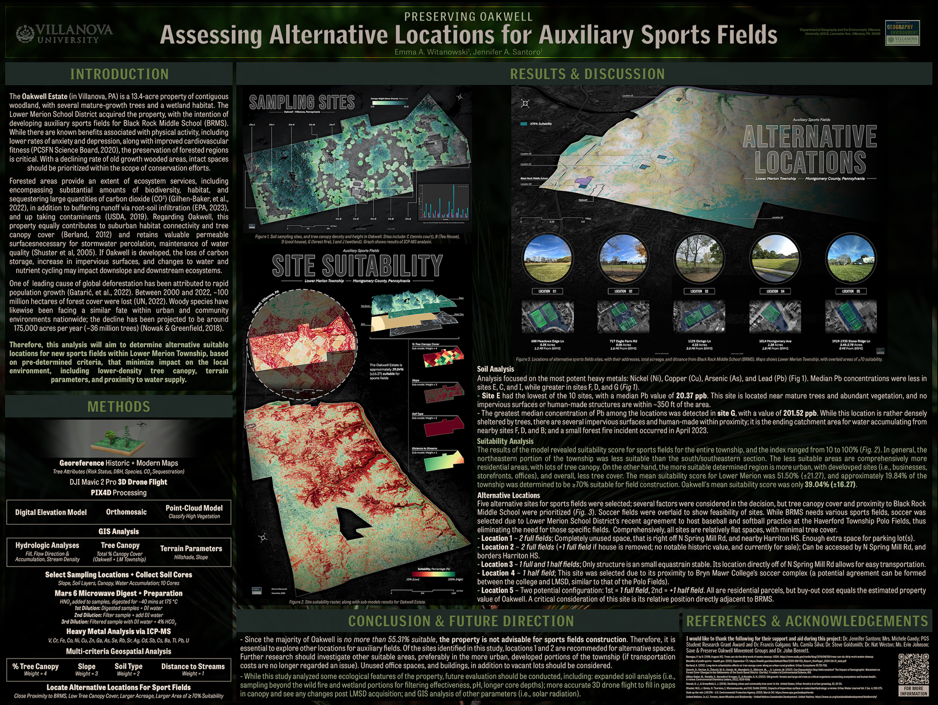
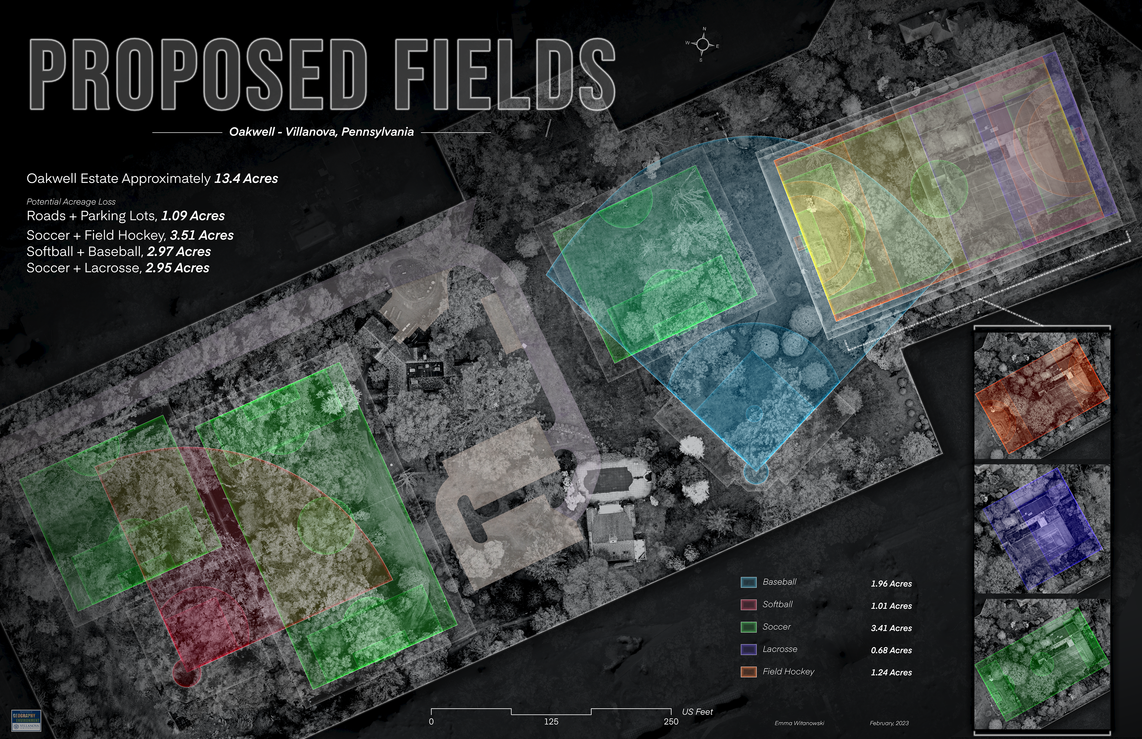
The Oakwell Estate, in Villanova, PA, is home to several mature-growth trees, in addition to a wetland habitat. With development plans proposing to clear-cut trees for auxiliary sports fields for Black Rock Middle School, the localized ecological implications (and equally historical significance of Oakwell), coupled with national deforestation trends, warrant the need to consider alternative locations. This study measured pre-development environmental parameters and assessed sport field site suitability of Lower Merion Township. 1921 maps of the property were georeferenced to evaluate historic forest conditions and compared to modern surveyed inventories and high-resolution 3D drone imagery. Tree Canopy Cover data was used to analyze township tree patterns. Additionally, soil sampling was conducted across the property, and samples were analyzed for heavy metals using an Inductively Couple Plasma Mass Spectrometer (ICP-MS). Lastly, A multi-criteria decision analysis (MCDA), including criteria such as tree canopy cover, slope, soil type, and distance to streams, was constructed in GIS, to establish the suitability of township land for fields. Using the outputs of the model, alternative locations were determined. The results of the study found that Oakwell is only 39.04% (±16.27) suitable for sports fields. Tree canopy covers approximately 58.96% of the property but would be reduced to approximately 11.63% if clear-cut occurred. Heavy metals tended to be less concentrated near areas with tree cover and less impervious surfaces. Additionally, mean canopy cover in the township decreased by 4.2% over the last ten years. These parameters should be considered before deciding the ultimate fate of Oakwell.
Affiliation
Villanova University (Senior Thesis)
Advisor
Dr. Jennifer Santoro (Professor)
⎯⎯⎯⎯⎯⎯ ⎯⎯⎯⎯⎯⎯
Modern Environmental Impacts of Field Construction Using GIS*
Abstract
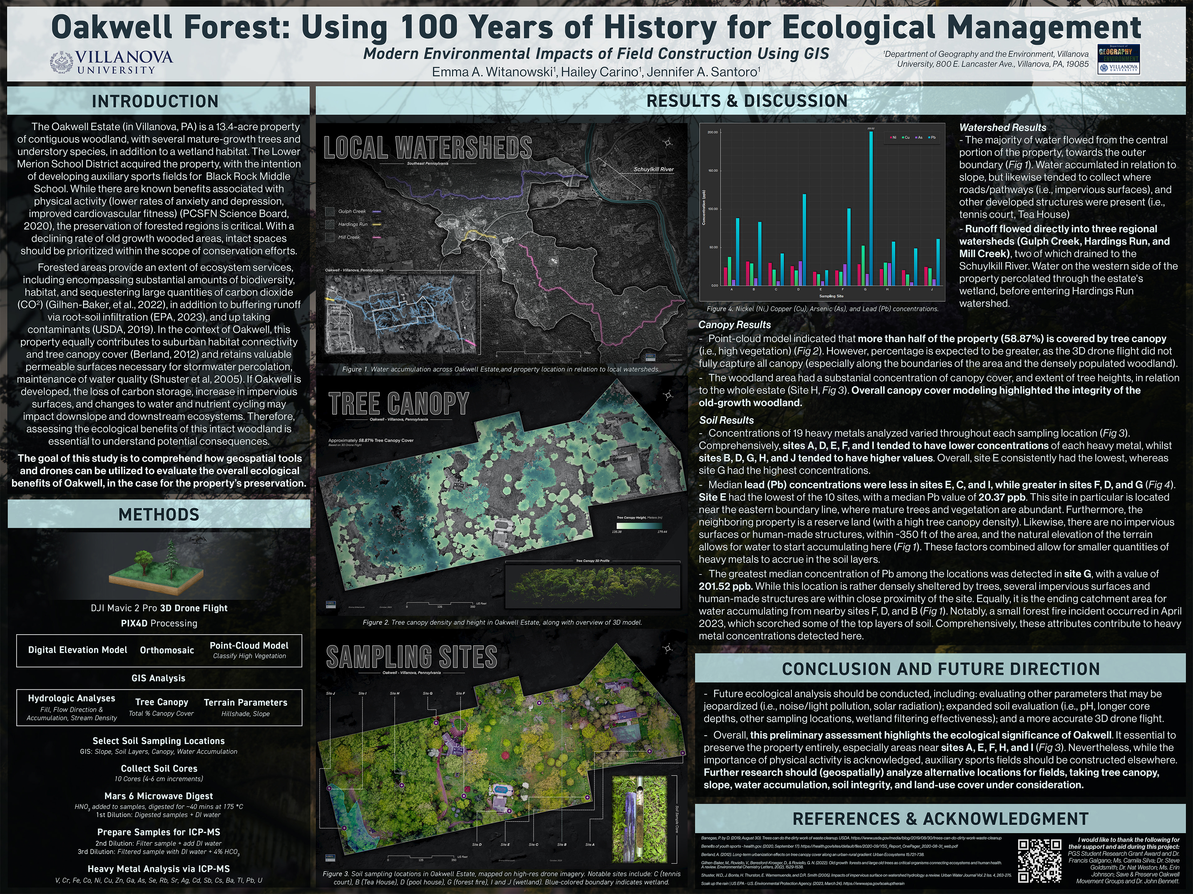
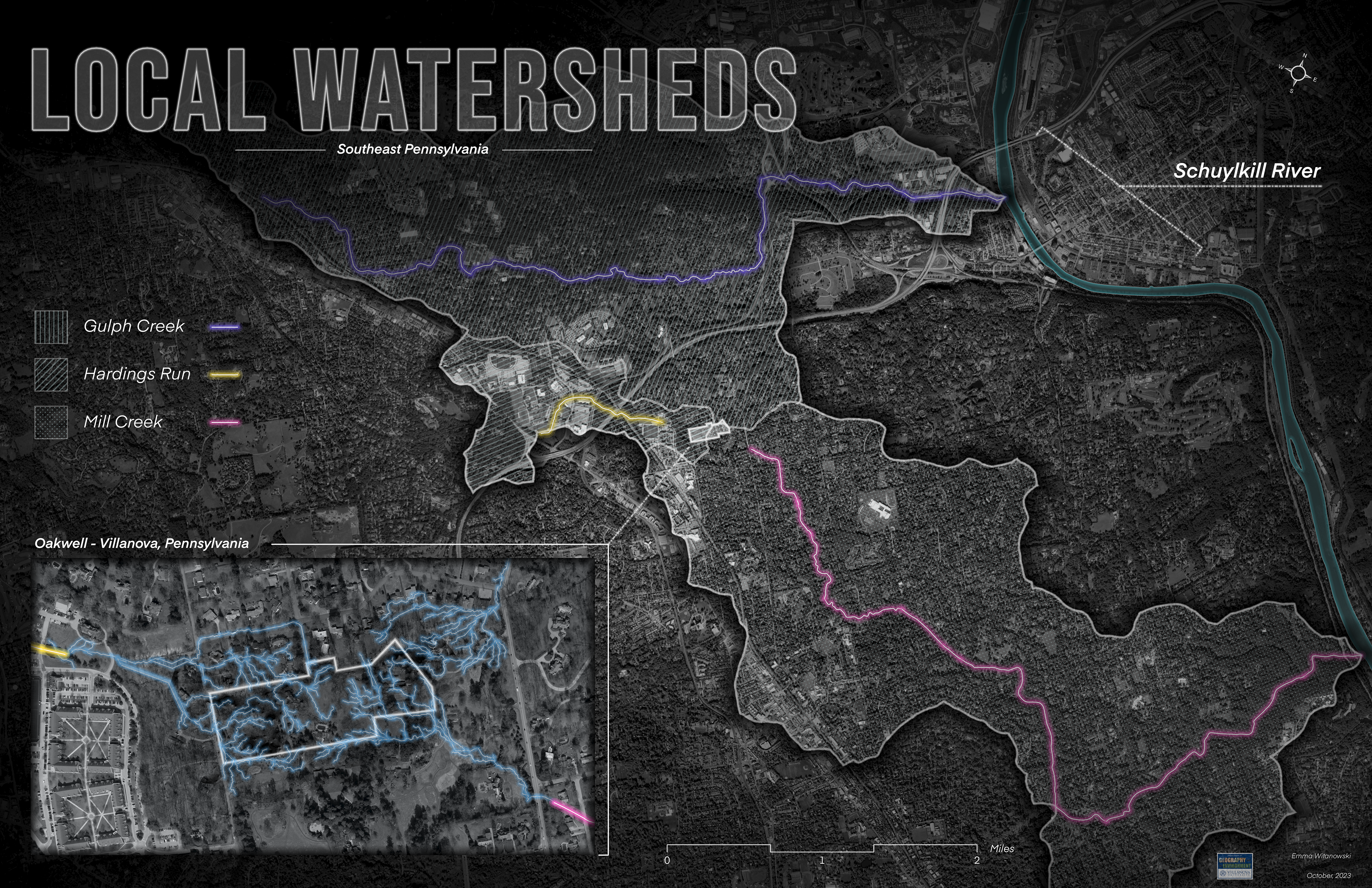
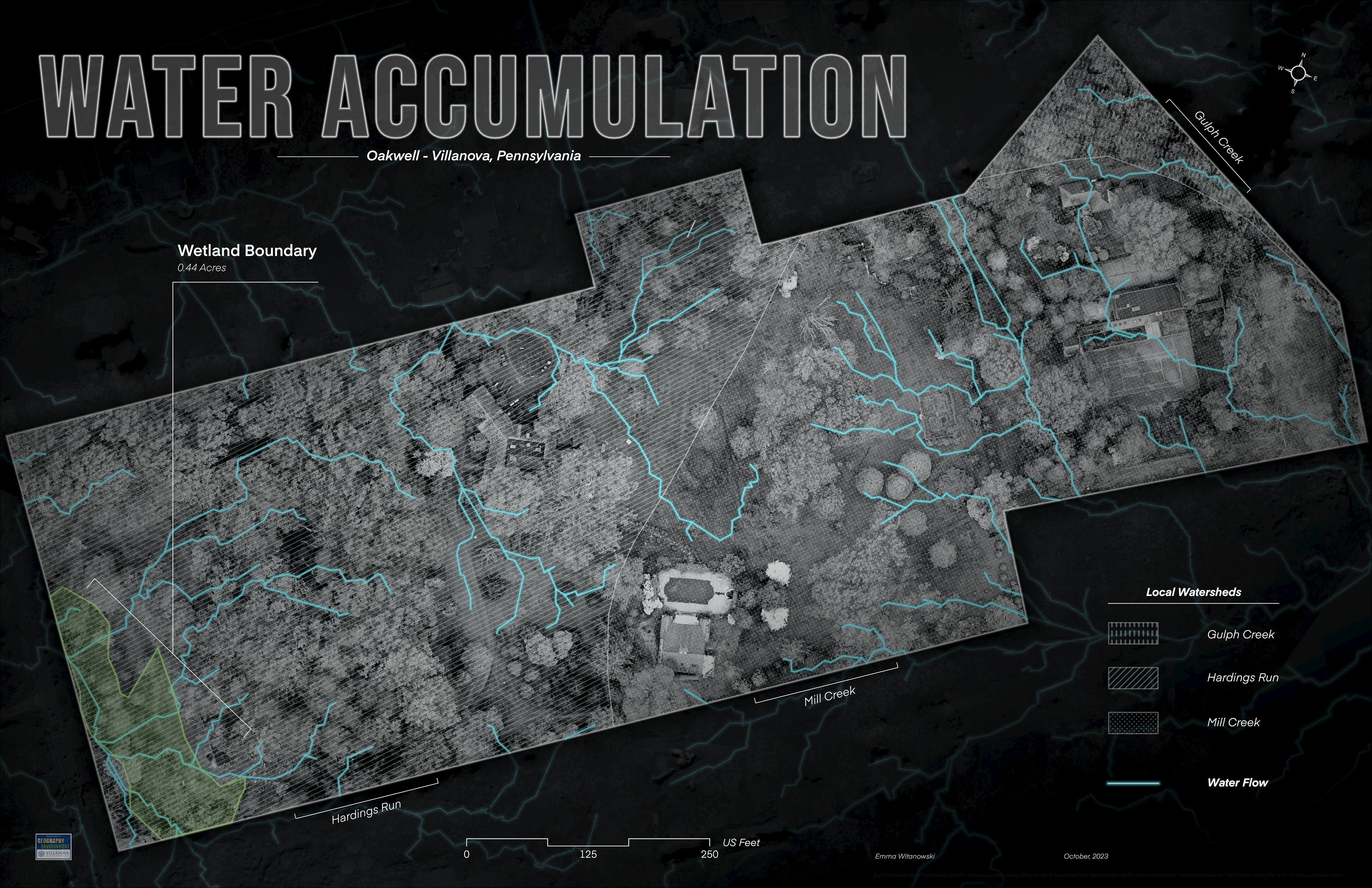
This project measured pre-development environmental conditions at Oakwell, located in Villanova, Pennsylvania, to determine the ecological value of the property. Oakwell is home to several mature-growth trees (over 100 years old) and understory species, in addition to wetland habitat. With development plans proposing to clear-cut trees for auxiliary sports fields, assessing the benefits of having an intact woodland amongst a surrounding suburban landscape is essential to understand potential consequences. A 3D drone flight was conducted with a DJI Mavic 2 Pro drone to create a point-cloud model, orthomosaic, and digital elevation model (DEM), and were analyzed via Geographic Information Systems (GIS) (e.g., water accumulation, tree canopy, terrain metrics). Soil sampling sites were selected considering slope, water accumulation, and relative location (under varying tree cover) and were analyzed for heavy metals (V, Cr, Fe, Co, Ni, Cu, Zn, Ga, As, Se, Rb, Sr, Ag, Cd, Sb, Cs, Ba, Tl, Pb, U) using an Inductively Couple Plasma Mass Spectrometer (ICP-MS). The results of the study found that water accumulation directly contributes to three local watersheds (Gulph Creek, Hardings Run, Mill Creek) and that tree canopy covers approximately 40% of the property. This ecological information should be considered before deciding the ultimate fate of Oakwell.
Affiliation
Villanova University
Pennsylvania Geographical Society (PGS)**
Advisor & Partner
Dr. Jennifer Santoro (Professor)
Hailey Carino (Villanova, '24)
* First Place in the PGS Elaine Bosowski Map Award, Undergraduate Poster
** Research funded by the Pennsylvania Geographical Society (PGS) Student Research Fund
⎯⎯⎯⎯⎯⎯ ⎯⎯⎯⎯⎯⎯
Oakwell Forest
Using 100 Years of History for Ecological Management

Statement
The goal of this project is to assess the ecological, historical, and educational value of the historic and woodland property, Oakwell (located in Villanova, Pennsylvania), using ArcGIS tools to marry historical data and maps to modern technology.
Affiliation
Villanova University
Course
GEV 2893: Independent Study