Preserving Oakwell – Assessing Alternative Locations for Auxiliary Sports Fields
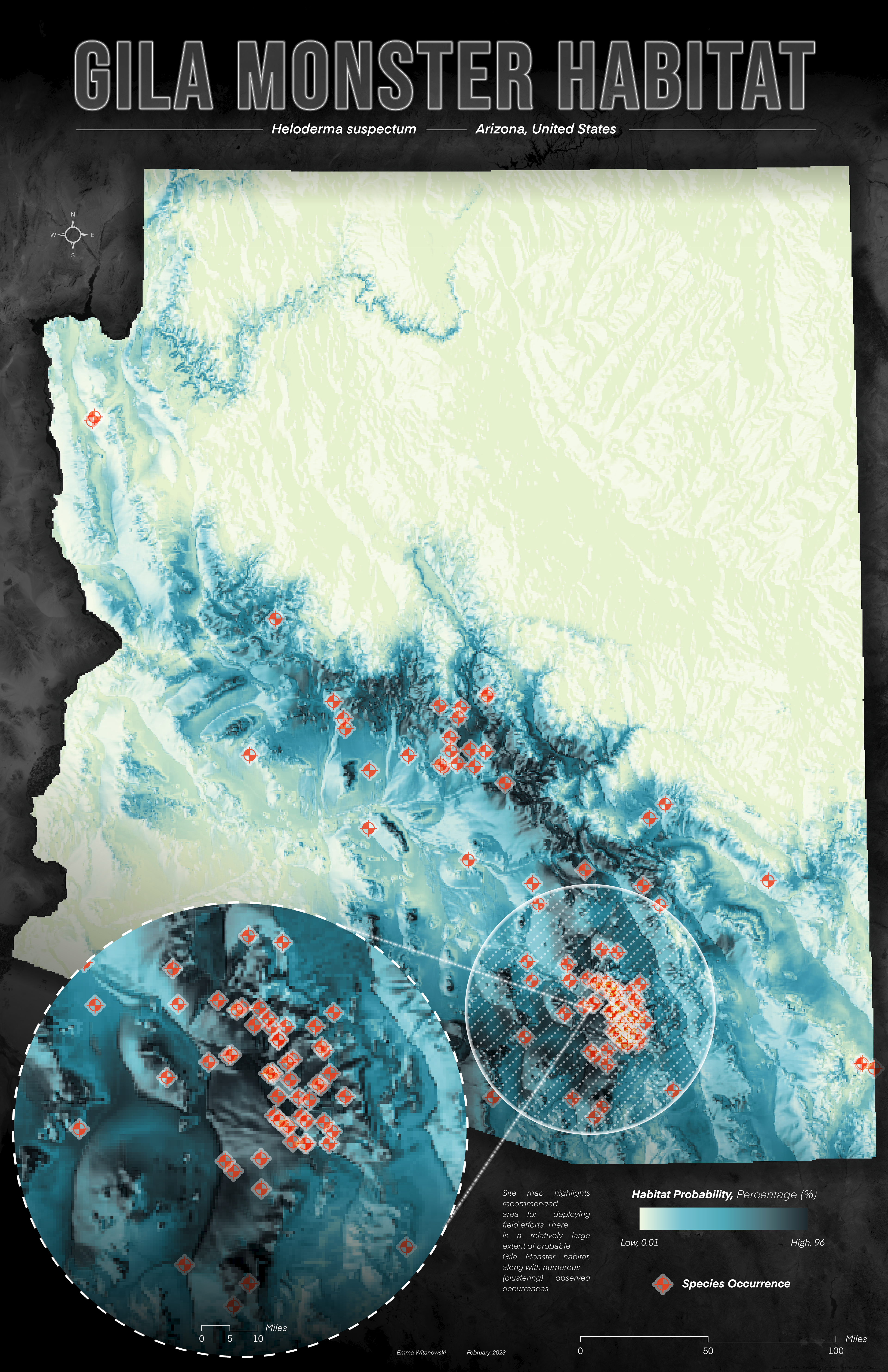
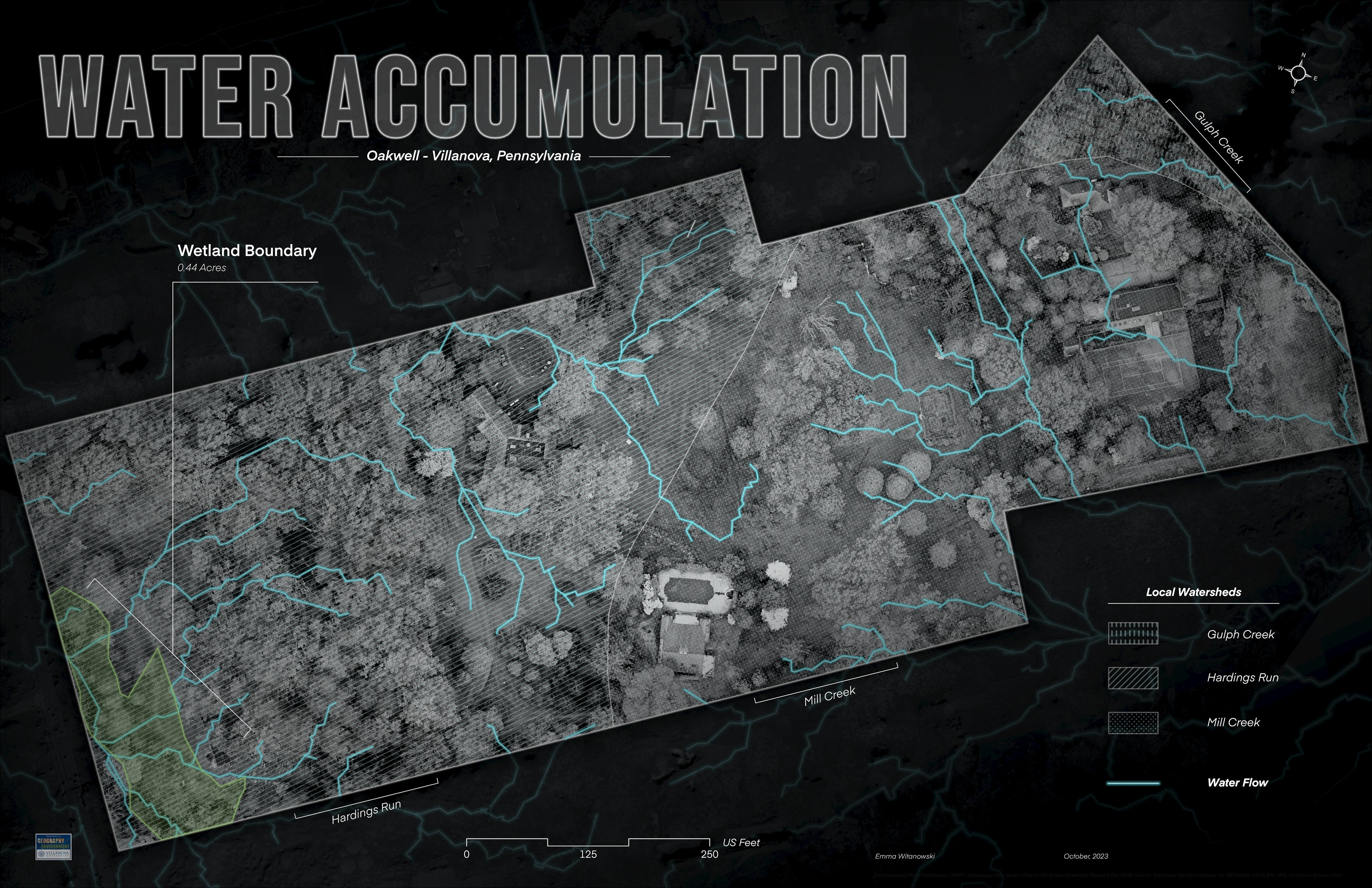
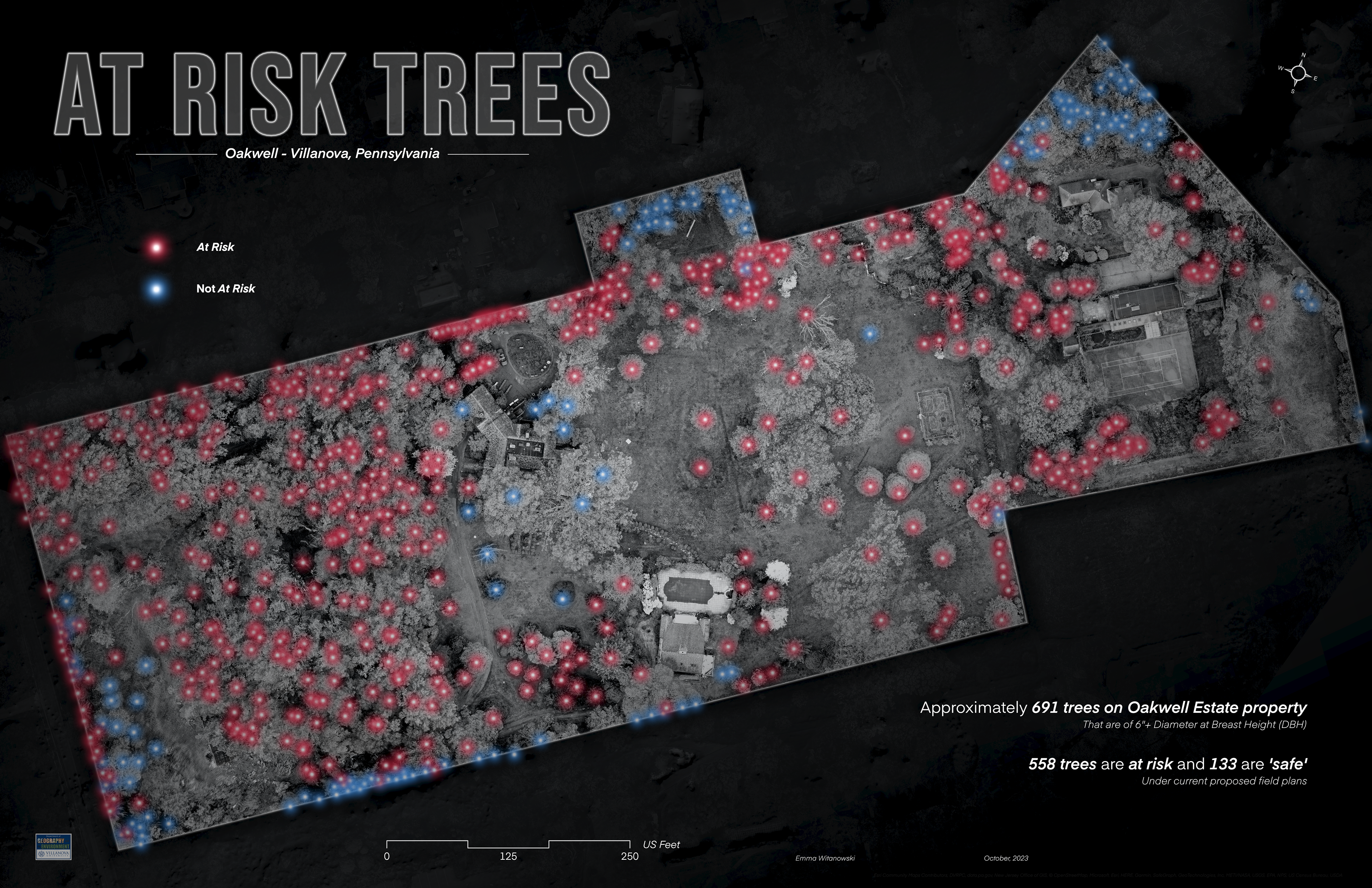
Abstract: The Oakwell Estate, in Villanova, PA, is home to several mature-growth trees, in addition to a wetland habitat. With development plans proposing to clear-cut trees for auxiliary sports fields for Black Rock Middle School, the localized ecological implications (and equally historical significance of Oakwell), coupled with national deforestation trends, warrant the need to consider alternative locations. This study measured pre-development environmental parameters and assessed sport field site suitability of Lower Merion Township. 1921 maps of the property were georeferenced to evaluate historic forest conditions and compared to modern surveyed inventories and high-resolution 3D drone imagery. Tree Canopy Cover data was used to analyze township tree patterns. Additionally, soil sampling was conducted across the property, and samples were analyzed for heavy metals using an Inductively Couple Plasma Mass Spectrometer (ICP-MS). Lastly, A multi-criteria decision analysis (MCDA), including criteria such as tree canopy cover, slope, soil type, and distance to streams, was constructed in GIS, to establish the suitability of township land for fields. Using the outputs of the model, alternative locations were determined. The results of the study found that Oakwell is only 39.04% (±16.27) suitable for sports fields. Tree canopy covers approximately 58.96% of the property but would be reduced to approximately 11.63% if clear-cut occurred. Heavy metals tended to be less concentrated near areas with tree cover and less impervious surfaces. Additionally, mean canopy cover in the township decreased by 4.2% over the last ten years. These parameters should be considered before deciding the ultimate fate of Oakwell.

Modern Environmental Impacts of Field Construction Using GIS
Abstract: This project measured pre-development environmental conditions at Oakwell, located in Villanova, Pennsylvania, to determine the ecological value of the property. Oakwell is home to several mature-growth trees (over 100 years old) and understory species, in addition to wetland habitat. With development plans proposing to clear-cut trees for auxiliary sports fields, assessing the benefits of having an intact woodland amongst a surrounding suburban landscape is essential to understand potential consequences. A 3D drone flight was conducted with a DJI Mavic 2 Pro drone to create a point-cloud model, orthomosaic, and digital elevation model (DEM), and were analyzed via Geographic Information Systems (GIS) (e.g., water accumulation, tree canopy, terrain metrics). Soil sampling sites were selected considering slope, water accumulation, and relative location (under varying tree cover) and were analyzed for heavy metals (V, Cr, Fe, Co, Ni, Cu, Zn, Ga, As, Se, Rb, Sr, Ag, Cd, Sb, Cs, Ba, Tl, Pb, U) using an Inductively Couple Plasma Mass Spectrometer (ICP-MS). The results of the study found that water accumulation directly contributes to three local watersheds (Gulph Creek, Hardings Run, Mill Creek) and that tree canopy covers approximately 40% of the property. This ecological information should be considered before deciding the ultimate fate of Oakwell.
Research funded by the Pennsylvania Geographical Society (PGS) Student Research Fund
First Place in the PGS Elaine Bosowski Map Award, Undergraduate Poster
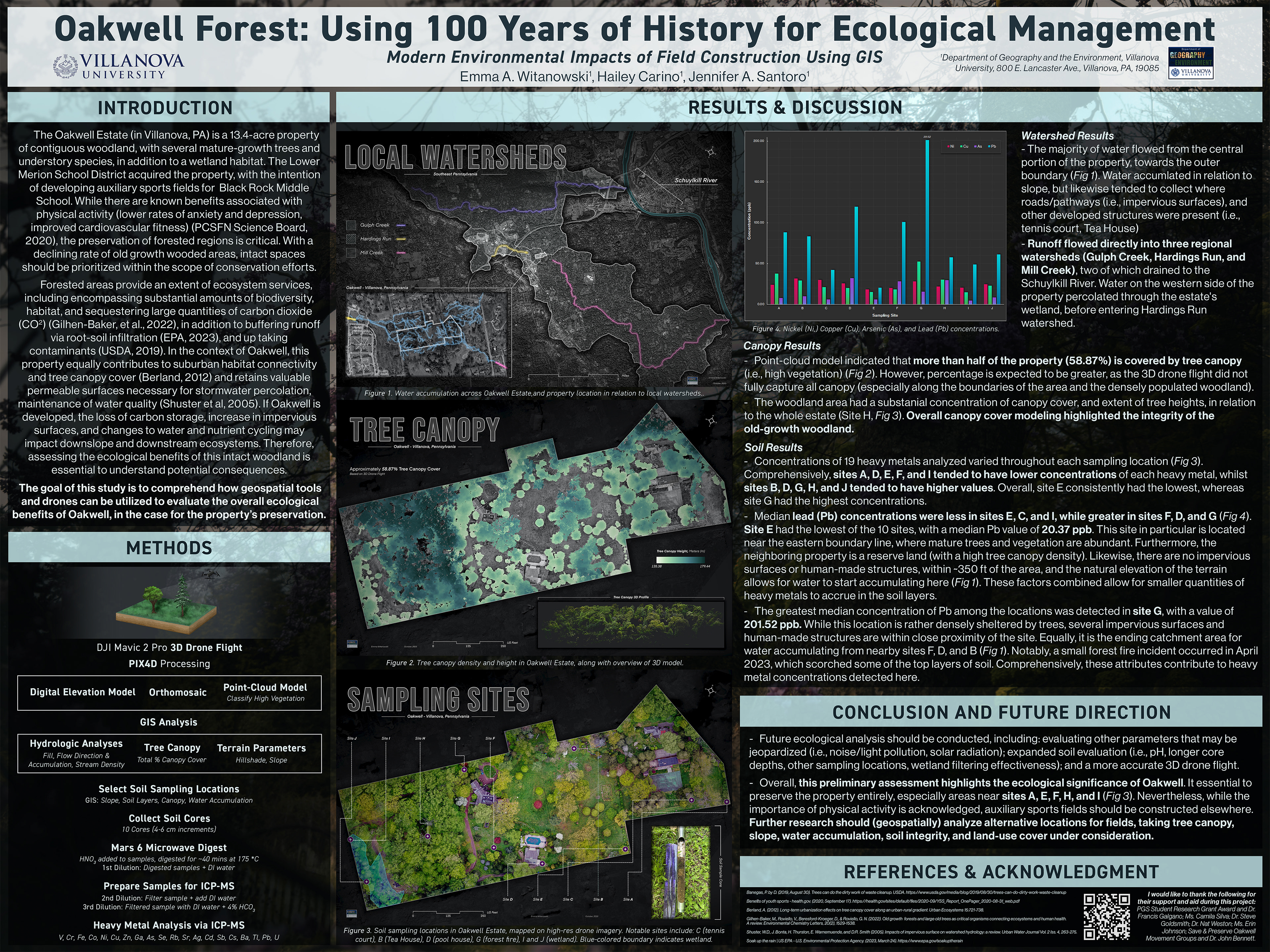
Oakwell Forest: Using 100 Years of History for Ecological Management
The goal of this project is to assess the ecological, historical, and educational value of the historic and woodland property, Oakwell (located in Villanova, Pennsylvania), using ArcGIS tools to marry historical data and maps to modern technology.


Natural Hazards and Societal Impacts
Tornado Climatology and Population Risk
Tornadoes, along with other weather events, are natural and neutral phenomena. However, with rapid population growth and vast spatial development, such events transform into [natural] hazards. In general, severe weather events comprise 75% of annual deaths and property destruction. Furthermore, approximately 80% of [global] property insurance claims are associated with weather events. In 2021 alone, weather-related insurance industry losses amassed $120 billion USD, with insured losses from tornadoes equaling $4 billion in December (Evans 2022). In addition to economic loss, there were 104 fatalities linked to tornado events in 2021 (NWS). Thus, with contemporary migration to tornado-prone regions, the implications of economic loss and human fatalities need to be critically considered.
Tool Highlights
Proportional Splitting (Intersect), Fishnet Grid, Select By Attribute, Spatial Join, Table Join, Point To Raster

Hydrologic Processes
Watershed Delineation and Contamination
While watersheds play a critical role in the Earth’s hydrologic cycle, contemporary human practices and development jeopardize the integrity of the water within these regions. Streams within watersheds provide many benefits, including drinking water supply, electricity production, and crop irrigation (WSS, 2019). While there are various forms of naturally induced mechanisms that may alter stream flow (i.e., snowmelt, evaporate on, groundwater recharge) human-stimulated variations have drastically increased runoff rates in recent years. An increasing percentage of impervious surfaces (and overall land use change), coupled with continual use of road salts (and other polluting contaminants) poses risks to not only the environment but also human and organismal health. Approximately 14,000 people die daily due to the implications surrounding water pollution (Chaudhry & Malik, 2017).
Tool Highlights
Raster Calculator, Slope, Hillshade, Aspect, Contour Lines, Extract By Mask, Fill, Flow Direction, Flow Accumulation, Watershed, Stream Order, Stream To Feature
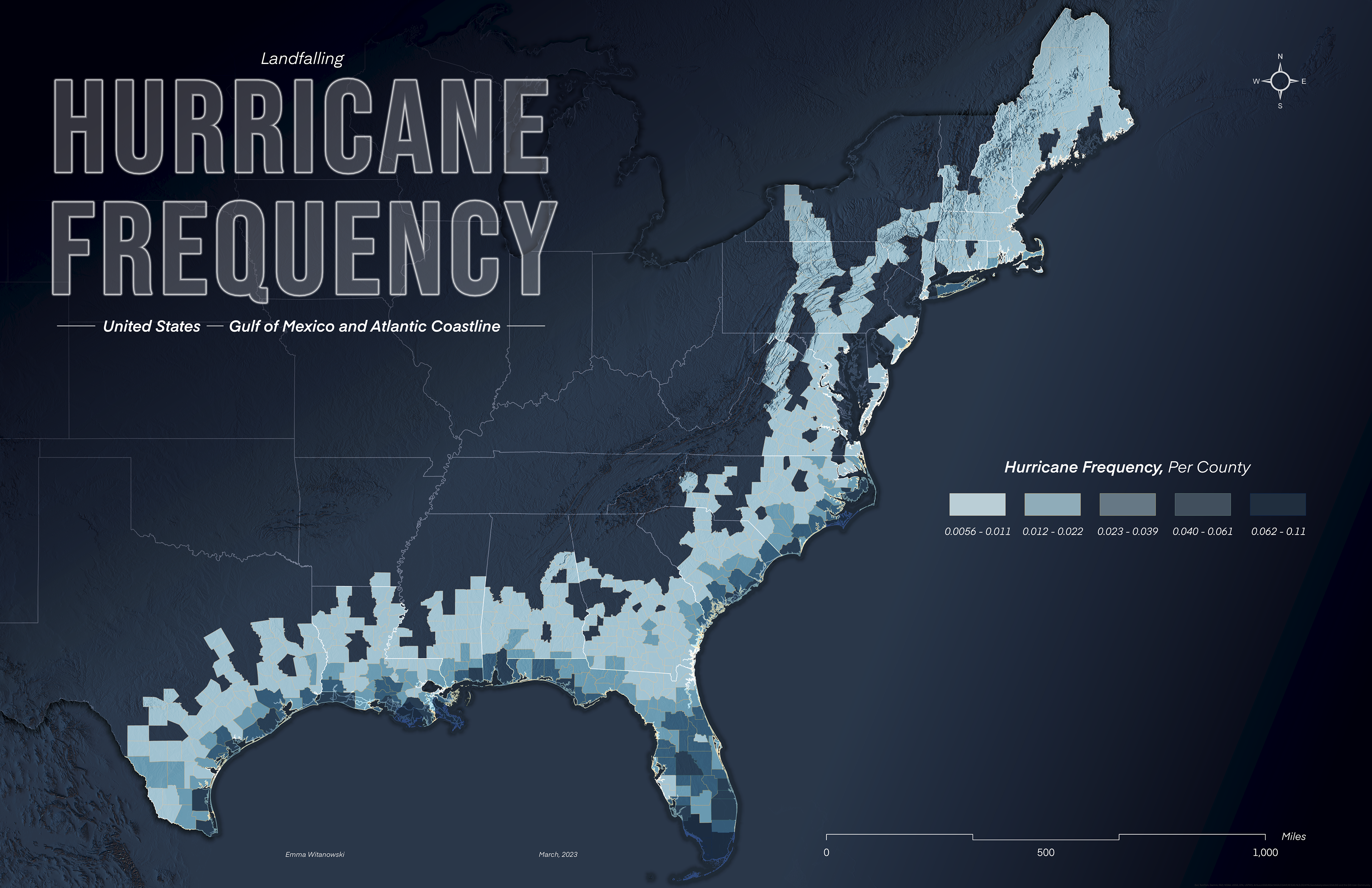
Coastal Hazards and Processes
Natural Hazard Vulnerability and Shoreline Migration
Recent development within coastal counties has not only endangered the relative landscape, the but also has positioned larger populations within naturally vulnerable areas. Coastal shorelines are dynamic landforms that naturally erode and grow, thus not providing suitable foundations for any development. Between 2013 and 2050, an estimated $60-63 billion USD will be lost in major cities adjacent to coastal zones (Vazquez-Conzalez, et al., 2019). While contemporary interventions aim to prevent natural migration, other implications concerning hurricane storm surge equally pose a risk for inhabitants. Overall, if current trends persist, a greater portion of the population will be inhabiting these greater-risk zones.
Tool Highlights
Reclassify, Spatial Join, Select By Attribute, Extract By Mask, Create Feature Layer (Digitizing)

Climate Change Projections
Atmospheric, Oceanic, and Societal Impacts
Climate change is a critically significant contemporary environmental threat. The concept of climate change is often mislabeled and referred to as “global warming”—the relative trend of an accelerating warming globe. Historically, Earth’s mean temperatures have increased by 0.14 °F, per decade, since 1880; but since 1981, the rate has increased to 0.32 °F (Lindsey & Dahlman, 2023). Nevertheless, warmer temperatures are only a single facet within the scope of a larger issue, as various aspects of the natural environment are likewise changing. Likewise, the extent and degree of implications are highly localized. For instance, the Arctic region dubbed the “fingerprint of climate change,” is experiencing warming four times faster than other regions (Bamber, 2022).
Tool Highlights
Buffer, Extract by Mask, KML to Features, Plot X/Y, Subset Multidimensional Raster
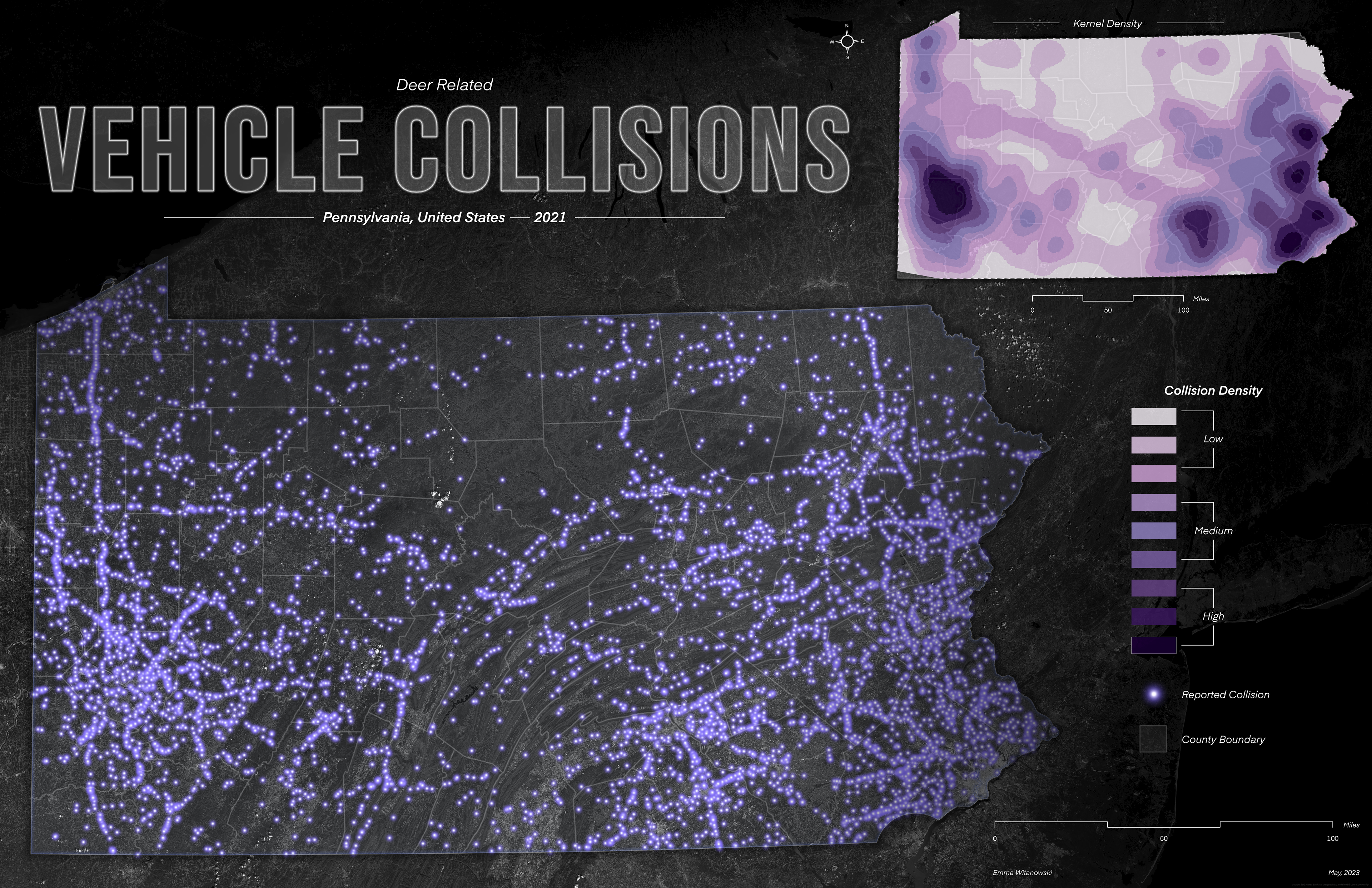
Environment and Society Interactions
Implications of Wildlife Vehicle Accidents
Human encroachment on natural habitat (i.e., land use change, development), in combination with increased populations s certain species, has contemporarily put drivers in a more vulnerable position concerning car-wildlife collisions. There are approximately 1-2 million documented incidents, per year, involving vehicles and large animals in the United States, with 200 [human] deaths and 26,000 associated injuries (Skroch & Hilaire, 2021). Between July 2020 and June 2021, 2.1 million animal collisions ensued. Compared to the previous 12-month period, accidents were projected to have increased by 7.2% (Ortega, 2022). While there is a plethora of species that have been involved in such crashes, white-tail deer remain the most common (Schneck, 2022).
Tool Highlights
Kernel Density, Extract by Mask, Spatial Join, Table Join, Select By Attribute

Landscape Dynamics
Land Use, Impervious Surface, and Tree Canopy Change
Within a contemporary context, continuous population growth has promoted an upsurge in land development. In relation to these trends, overall land cover has significantly been altered. It is estimated that 32% of global land has been affected by (human) land use change activities between 1960 and 2019 (Winkler, et al., 2021). Subsequently, forested regions tend to be at the forefront of such alterations, with the leading cause of [global] deforestation being attributed to rapid population growth (Gatarić, et al., 2022). Between 2000 and 2022, approximately 100 million hectares of forest cover were lost, with a relative decrease of 31.9 to 31.2% of the total global area constituting this land cover (UN, 2022). Woody species have likewise been facing a similar fate within urban and community environments nationwide; the decline has been projected to be around 175,000 acres per year (which translates to 36 million trees) (Nowak & Greenfield, 2018). Furthermore, a correlation between impervious surface gain, in relation to tree canopy loss was observed in urban and community spaces, ranging from +0.6-1.0% growth from 2009 to 2014 (Nowak & Greenfield, 2018). Globally, impervious surface cover has increased from approximately 1.27 to 1.29 million km2 between 2015 and 2018 (Sun, et al., 2022).
Tool Highlights
Reclassify, Extract By Mask, Buffer, Plot X/Y

"Quest For The Golden Toad"
Geospatial Analysis for Habitat (Story Map)
These magnificently bright orange creatures were once commonly spotted congregated in large groups near small vernal pools during seasonal breeding periods. Yet, within the span of a year, known populations dropped from approximately 1'500 to just one lone male. Their brief appearance in history has left their rapid decline a 30-year-old mystery.
The shroud of mystery surrounding the origin of the toad's disappearance does provide a margin of hope concerning their contemporary survival. A plausible migration narrative should steer exploration efforts beyond the boundaries of the last-known spotting. Therefore, isolating similar ecoregions to the Monteverde Cloud Forest Reserve will provide an essential preliminary scope of where succeeding search expeditions should transpire.
To identify additional plausible habitat areas for Golden Toads throughout Costa Rica, a Species Distribution Model (SDM) analysis was performed. ArcGIS Pro was used for pre-and post-processing data, while Maxent was employed to create the model.
Programs: MAXENT & ArcGIS Pro
Skills & Tools: Species Distribution Model, Terrain Analysis